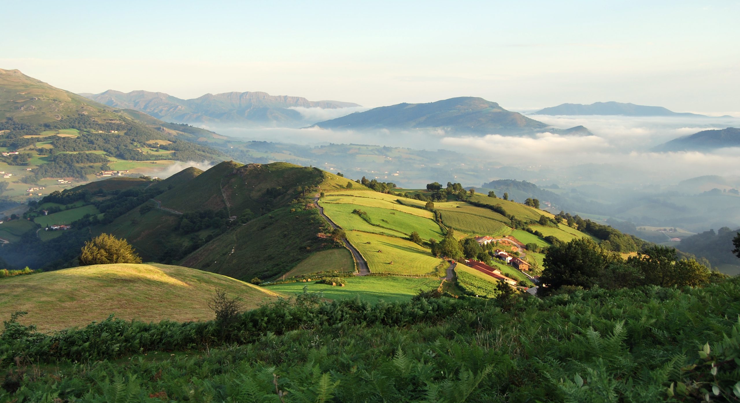
The Roman roads
In 450 B.C., the law of the 12 tables is enacted by the decemvirs: the 7th table is about the maintenance of roads. This shows the importance that the Romans gave to roads: on the other hand, they were conquerors from the beginning. The ancient Romans built long roads to connect the most distant provinces to the capital. Built as straight as possible to minimise distances, this infrastructure was essential for the growth of the empire, allowing its army to move quickly, enabling the administration of distant territories and the rapid movement of goods and people. The network of Roman roads was the most efficient and durable road system of antiquity.
The oldest and most important roads were the VIAE PUBLICAE, commonly called CONSOLARIES, which connected the main cities. They were named after the magistrate who ordered their construction: Flaminia (Rimini), Cassia (Florence), Aurelia (Pisa), Appia, Postumia, Clodia; or according to their use (Salaria) or the place where they ended (Ardeatina). Maintenance was entrusted to state officials.
In addition to the network of viae publicae, there were numerous roads of regional interest, the viae vicinalis or viae rusticae, which connected smaller settlements, including the Via Emilia Scauri. Their maintenance was entrusted to the local administrations. Finally, there were the viae privatae, which were of local interest and maintained at the expense of the communities or individual citizens who used them.
Every 20 miles (=1000 steps = 1,480 metres) there were the MANSIONES, resting places for public officials. In between were the MUTATIONES for changing horses, mules and oxen. For ordinary travellers there were the TABERNAE, our inns.
Major engineering works were carried out to build the roads, bridges, tunnels and embankments. Every mile was marked with a milestone showing the distance to the next town.
To cross the Alps, Augustus built the Via Julia Augusta (from Piacenza via Nice to Arles), the Via Publica (or Via delle Gallie) from Aosta to the Petit St Bernard reaching Lyon, or the Grand St Bernard to Martigny; all in all, an extremely modern organisation, as effective and appropriate as the solutions found.
After the decline and fall of the Roman Empire, the consular roads generally fell into disrepair for lack of maintenance (flooding of rivers, landslides, collapse of bridges), for a decline in traffic and for creation of a network of smaller alternative roads.
The Lombards
They conquered most of Italy: Alboin, Agilulf, Rotari, Liutprand, Desiderius. Initially Arian, they became Catholic and integrated well with the Italian population. Part of the Italian territory remained with the Pope and the Byzantines. Communication between north and south was interrupted or remained difficult. It was therefore necessary to move the communication routes to the western part of the Apennines: the Cisa Pass and the Cirone Pass. The main road became Lucca/Parma instead of the Cassia Florence/Bologna. The road along the Lunigiana became strategic.Many castles were built to defend it and their names are of Lombard origin: Radicofani, Montestaffoli (San Gimignano), Salamarthana (Fucecchio), Sorano in Filattiera, Aghinolfi at Montignoso. The Lombard kings relied heavily on the monasteries and abbeys, also as safe resting places, footholds and hospices for pilgrims and travellers, who were present in large numbers along the route. From the 7th century, therefore, there is evidence of the existence of an important road linking the two parts of the Lombard kingdom, avoiding the coasts and areas controlled by the Byzantines. The first evidence of pilgrimages from France to the Limina Petri date back to the 7th/8th century. The passes used were Mont Cenis and the Great St Bernard, the easiest points to cross the Alps. Paul Deacon, in his Historia Longobardorum (789), says: “In those times, many noble and ignoble persons, men and women, lords and commoners, came, driven by divine love, from Brittany to Rome”. The expansion of the Lombards threatened Rome. First Pepin, then Astulf waged war against the Pope, who asked the Franks for help. Charlemagne intervened, marking the beginning of the end of the Lombard domination and the beginning of Frankish rule. The road that crossed the Cisa (then called Monte Bardone) became even more strategic and was called “Francigena” or “Francesca” because it came from France.
The Franks
At that time, both the East Franks (from Germany) and the West Franks (from France) were called ‘Franks’. It was only after the end of the Holy Roman Empire (843) and the division of the two territories that a distinction was made between them. The first documented use of the name ‘FRANCIGENA’ dates from 876. Later it was also used for roads leading to Rome and the north. The Franks continued the work of founding monasteries and royal abbeys: assisting pilgrims and travellers was considered a duty of the king. After the unification of Central and Western Europe under Charlemagne, the territory of Italy was gradually divided into several states. This situation was certainly not favourable to the construction of major roads and was an obstacle to trade and pilgrimages, which, however, did not stop.
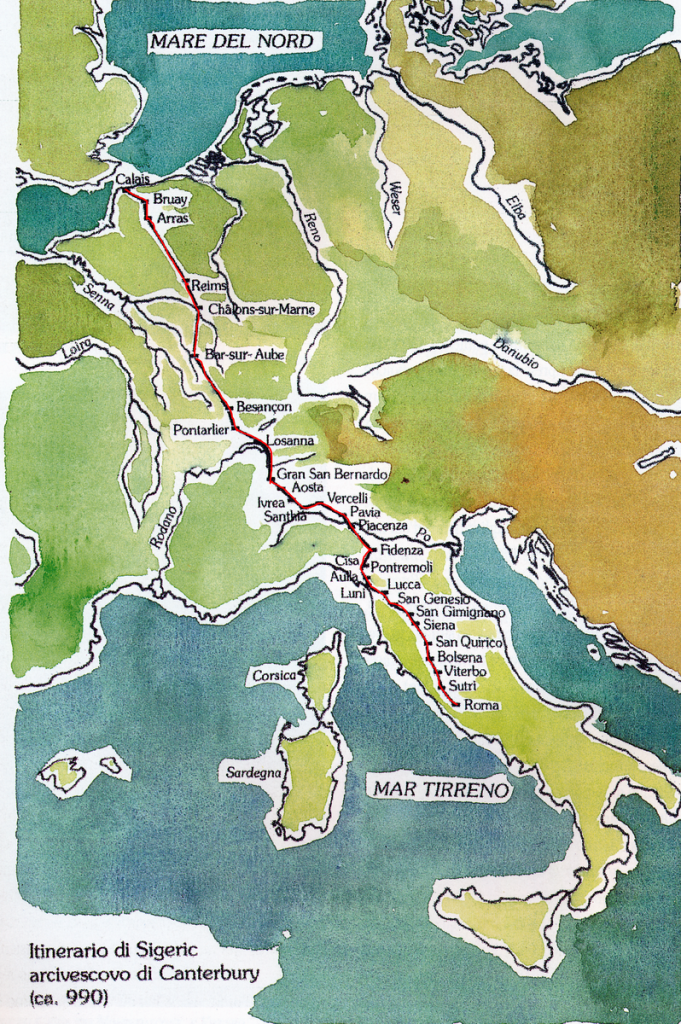 Sigeric
In the year 990, Sigeric, Bishop of Canterbury, is consecrated Archbishop; he set on his way to Rome to receive the “pallium”, a white woollen stole that had been given to archbishops for centuries (it symbolises the image of the shepherd caring for his sheep as Christ cares for people). He travelled to Rome and after a short stay returned to England. On this return journey he wrote an account of the places he passed through and where he slept (preserved in the British Library in London). We can therefore reconstruct his 79-day journey with great accuracy. The route chosen was the ancient Via Cassia to San Miniato, then Lucca, the foothills of the Apuan Alps, the Val di Magra, the Lunigiana, the Apennine pass of the Cisa and Fornovo. From here to Fidenza, Piacenza, Pavia, Vercelli, Ivrea and Aosta with the crossing of the Alps through the Great St Bernard Pass to Martigny. Then Besançon and straight across France via Reims to the English Channel at Suimeran. Nothing remains of the route on English soil.
Other evidence of pilgrimages comes from the Benedictine abbot Nikulas of Munkathvera, who travelled to Rome and then to the Holy Land in 1151/4, leaving a description in verse of the route and the cities he passed through. Another is by King Philip Augustus, who, returning from the Crusade in 1191, crossed Southern Italy, reached Rome and returned to France. The itinerary in Italy is essentially the same as that of Sigeric.
The tenth and eleventh centuries
The second millennium saw the beginning of the Pilgrimages to Santiago de Compostela. The Church of the time favoured pilgrimages to Santiago and to the holy places of Christianity, Rome and Jerusalem. The Via Francigena was used by Italian pilgrims on their way to Santiago. And, of course, it was used by the Crusader armies to reach the Apulian ports of embarkation for Palestine.
In Italy, the most popular pilgrimages were to.
- Our Lady of Loreto (14th century)
- The Holy Face of Lucca (8th century)
- St Michael in Gargano (6th century)
- St Nicholas in Bari (12th century)
- Sacred mountains
Pilgrims
Anyone who went on a long pilgrimage had to arrange for the administration of his estate and make a will. He also had to find the means to do so, perhaps by selling his goods and possessions or placing them under the guardianship of the Church (it was a right). Those who had nothing had to rely entirely on public charity.
The typical costume of the pilgrim, which is widely represented in iconography, consisted of
- a sanrocchino or schiavina or pellegrina (a short cloak of cloth, often waxed)
- a broad hat
- a saddlebag
- a pouch hanging from the waist
- a broadsword with metal tip
- a gourd for storing water
- a sign indicating the place of destination
The credential was, of course, essential: issued by the religious authority from which the pilgrim departed, it attested to the pilgrim’s status and therefore to his recognised right to assistance.
The type of pilgrimage could be
- devotional
- obligatory for the expiation of a sin (imposed by a confessor)
- compulsory to serve a sentence (imposed by a judge)
- substitute (on account of another person)
Orders of chivalry that protected pilgrims could be explicitly religious:
- Knights of the Tau – had monasteries, usually near rivers, with the task of maintaining bridges.
- Order of the Holy Spirit
- Bethlemites
- Crusaders
- Antonines
but even distinctly military
- Hospitallers of St John
- Teutonic Knights
- Templars (later Order of Malta)
From the first centuries of Christianity (6th century), places of hospitality called xenodochi were available, mainly for pilgrims and travellers. Later called hospices/hospitals, they became places for the sick, pilgrims, strangers, the poor and foundlings. They were not separate buildings, but structures attached to churches and monasteries, and were mainly located in important urban centres and at major road junctions. Some were small, consisting of one room and nothing more. From the 11th and 12th centuries, more specialised care structures began to appear, true hospital complexes (like Altopascio).
The 13th century
In the 13th century, the importance of the VF for trade and related financial activities was consolidated and established, for those who travelled to Rome or France and beyond, as well as for those who lived in places easily reached by roads departing from this route. The VF was thus one of the most important factors in the development of economic and social life in medieval Italy. Obviously, over time, alternative routes were created to cross the Alps (Simplon, St Gotthard, Brenner) and the Apennines. In addition, the main route saw the creation of route variants: hence the emergence of several Vie Francigene.
Of course, there was the problem of road maintenance and the control of the passage with the application of possible tolls.
In the 13th century, the flow of pilgrims to Rome began to decline. In 1300, Pope Boniface VIII proclaimed the first Jubilee, which brought large numbers of pilgrims to Rome and marked the beginning of a revival in the practice of pilgrimages. Giovanni Villani says that 200,000 people came to Rome, that the Ponte Sant’Angelo was divided into two lanes to allow people to pass more quickly, and that in those years there were 30 hospices in Rome with 1,000 beds. Even the number of accounts of journeys and pilgrimages increases.
In this century, the Florence/Bologna route also became popular. The passage of pilgrims along the VF had the cultural effect that every movement of people always has, because it brought together different countries, cultures, languages and customs. By their presence and their return, the travellers broke the isolation of the communities.
Along with people and goods, the VF transported ideas, spreading the models developed by the main cultural centres of the Christian world in Europe and the Mediterranean: aesthetic models, construction modules, political ideologies, religious movements spread more easily throughout Europe.
Via Francigena nowadays
The concept of the Via Francigena does not, therefore, refer to a simple road that can be precisely mapped on the territory, but to a set of routes that could change over time and that, over the centuries, linked the Italian peninsula to the Po Valley and, beyond the Alps, to France and other north-western European countries.
The VF began to be talked about in the mid-1990s: the Jubilee of 2000 can be considered the key year. At that time, many pilgrims went to Rome, individually, in small groups or organised in parish groups. The Church opened parishes and convents for the occasion. Many mayors opened gyms and schools for the summer. The state invested 3,500 billion lire, most of which went to Rome and Lazio. A long series of interventions were also financed in various parts of Italy, mainly for the restoration of religious buildings. Several pilgrim hostels have also been restored by the municipalities, but only a few have remained permanently in the possession of the pilgrims.
In 2001 the Italian Via Francigena Association was founded, whose members are the Italian regions, provinces and municipalities crossed by the route. In 2007, the association was opened to Swiss, French and English local authorities and became a European association.
In 2004, the Council of Europe declared the VF a ‘major cultural route’.
At the beginning of the 2000s, several associations scattered throughout the territory undertook to identify and mark the route. Due to the lack

of coordination, different itineraries appear in many places, indicated by signs of different colours and shapes. The Confraternity of San Jacopo di Compostella in Perugia published a guide and wanted to be a reference for the various associations in Italy.
In those years, first the Ministry of Culture (Minister Rutelli), then the Ministry of Agricultural Policies (Minister De Castro), then again the Ministry of Cultural Heritage and Activities (Minister Bondi) worked to define a precise route. A private company was then given the task of proposing, in agreement with the local authorities, a route suitable for those who wished to follow it. The criteria are:
- Following Sigeric’s itinerary, so that the route coincides as much as possible with the historical route.
- Visiting the most historically important places, unless excessive detours are necessary.
- Seeking routes that are as far away from traffic as possible, thus allowing for safe walking.